

SKU: 9781925625585PLU: 141016UPC/EAN: 9781925625585
Hema Great Desert Tracks Map Pack - Edition 8
or pay nothing today with

- Delivery
- In-Store
- Click & Collect
- description. press to scroll to the description section.
- features. press to scroll to the features section.
- specifications. press to scroll to the specifications section.
- warranty. press to scroll to the warranty section.
- reviews. press to scroll to the reviews section.
description
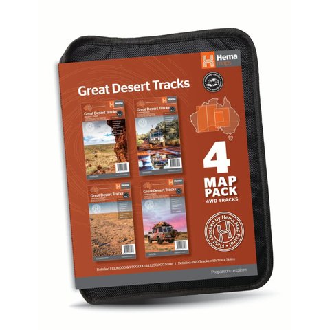
The HEMA Great Desert Tracks Map Pack - Edition 8 is the ultimate navigation tool for travellers exploring Australia’s arid heartland. Featuring Hema’s iconic Great Desert Tracks series, this pack comes housed in a soft yet rugged map wallet designed for the demands of off-road and remote travel. Each map is waterproof, tear-resistant and field-checked by the Hema Map Patrol, ensuring exceptional accuracy and reliability when it matters most.
With detailed coverage of Central, Eastern, Western and Simpson Desert regions, these maps feature marked 4WD tracks, distance markers, topographic relief, and touring information such as campsites, fuel stops, and caravan parks. Also included is vital information on desert travel preparations, including gear recommendations and key contacts. Whether you’re planning a solo expedition or a group journey, this map pack is an essential companion for navigating Australia’s vast and remote interior.
features
- Complete Desert Coverage: Includes four detailed maps – Central, Eastern, Western and Simpson Desert sheets
-
Great Desert Tracks Central Sheet (RRP $15.95)
The Great Desert Tracks Central Sheet covers from Judbarra/Gregory National Park in the north to Ceduna in the south, and from Halls Creek in the west to Coober Pedy in the east.
Key tracks include: Googs Track, Nullarbor Plain, Oodnadatta Track, Anne Beadell Highway (East), Tanami Road, Gary Junction Road, Sandy Blight Junction Track.
-
Great Desert Tracks Eastern Sheet (RRP $15.95)
The Great Desert Tracks Eastern Sheet covers from Tennant Creek in the north to Port Pirie in the south, and from Cunamulla in the east to Alice Springs in the west.
Tracks covered include: Oodnadatta Track, Birdsville Track, Strzelecki Track, Nullabor Plain, Corner Country, Lake Eyre, Simpson Desert, Plenty Highway, Sandover Highway, Channel Country, Hay River Track
-
Great Desert Tracks Western Sheet (RRP $15.95)
The Great Desert Tracks Western Sheet covers from beyond Derby in the north to Norseman in the south, and from Halls Creek in the east to Marble Bar in the west.
Key tracks include: Gunbarrel Highway, Great Central Road, Connie Sue Highway, Anne Beadell Highway (West) Nullabor Plain, Canning Stock Route, Talawana Track, Great Sandy Desert
-
Great Desert Tracks Simpson Desert (RRP $15.95)
Discover the Simpson Desert with detailed mapping, relevant points of interest and essential touring information for the journey. One side of the map covers the desert at a scale of 1:500,000, while the other is at 1:1,000,000 for planning purposes.
Tracks include: Madigan Line, French Line, Rig Road, WAA Line, K1 Line, Warburton Track, Hay River Track.
-
- Field-Checked Accuracy: All maps verified by the Hema Map Patrol for reliability and detail
- Durable & Waterproof: Printed on tough, tear-resistant and waterproof paper ideal for outback conditions
- Touring Info: Marked 4WD tracks, distance markers, fuel stops, campsites, caravan parks and key facilities
- Simpson Desert Map: Dual-scale (1:500,000 & 1:1,000,000) for navigation and trip planning
- Handy Map Wallet: Protective case included to store up to 10 maps in one secure place
- Essential Travel Info: Guidance on desert travel preparations, safety tips, and contact details
- Edition 8: Latest release offering updated mapping and track information
specifications
| Dimensions (L) x (W) x (H)cm: | 30 x 25 x 5cm |
| Weight: | 2kg |
warranty
12 month warranty